 Families
 New Families
 Alumni
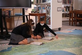
Grade 3 classes have started their latest IB PYP Unit of Inquiry, ‘How we express ourselves,’ by using the Canada C3 Giant Floor Map. They’ve begun exploring the central idea of ‘signs and symbols facilitate local and global communication.’
The giant (5×4 metre) Canada C3 Map was on loan from the Royal BC Museum for a week. It was created by the Canadian Geographic Society as part of the Canada Coast to Coast to Coast journey (Canada C3). The route of the Canada C3 journey is highlighted along with Parks Canada National Heritage sites, UNESCO World Heritage sites, migratory bird sanctuaries, national wildlife areas and marine protected areas. The provinces, territories and provincial capitals are also indicated.
The Grade 3 students were able to put on their detective hats during the final day of map’s stay on campus, as they worked their way through a scavenger hunt on the map as a way to start their new Unit of Inquiry.
“We have been trying to find certain things on the C3 Map,” said Conner ’31. “We are trying to find things like parks, bird sanctuaries, capitals of provinces and different places like a mixed forest. I’m enjoying the scavenger hunt and being able to look around Canada and see what different places are and looking for these specific places.”
Conner added that an interesting thing he found on the map was a UNESCO World Heritage site, which he is looking forward to learning more about.


“We are having fun on the scavenger hunt to find symbols on the map,” explained Annika ’31. “It’s really fun to look at the big map.”
“It’s super fun seeing how big Canada is,” added Harida ’31. “I think the best thing to find is the migratory bird sanctuaries.”
Related Posts
Why Every Student Should Participate in Model UN
As you’re probably aware, there’s a significant amount happening around the world right now. We stand at a crossroads,...
Grade 4 Students Break Codes to Discover Who We Are
Grade 4 students have stepped into the role of “code breakers” as part of their current IB PYP Unit...
GNS IB Diploma Students Celebrate Exceptional Exam Results
For almost 30 years, GNS has been at the forefront of nurturing personal and academic excellence through its participation...